Mason County, WV - An Archaeological Treasure |
||||||||||||||||
|
||||||||||||||||
 12th
Annual Report of the 12th
Annual Report of the Bureau of American Ethnology (1985 [1894]) |
Burial MoundsIn the 1880s, the Bureau of American Ethnology of the Smithsonian Institution conducted extensive excavations of some of the thousands of mounds and earthworks in the Ohio River Valley. The explorations were supervised by Cyrus Thomas, and in West Virginia, were conducted by Col. P.W. Norris. The results of the explorations were published in 1894 as the Report on the Mound Explorations of the Bureau of Ethnology (Thomas 1985 [1894]).
|
|||||||||||||||
|
The burial mounds in the Kanawha Valley were primarily built after 500 B.C. and have been attributed to the Adena culture that flourished in the Ohio Valley during the Woodland Period. Some of the mounds also contained artifacts from the Hopewell complex that succeeded the Adena and reached a greater level of accomplishment. Remnants of the monumental earthworks built by the Hopewell still exist in Ohio. The Kanawha Valley between Charleston and Institute was once the site of the largest complex of Woodland mounds and earthworks east of the Ohio River. The South Charleston mound is one of the few remaining mounds from that complex.
|
 |
|||||||||||||||
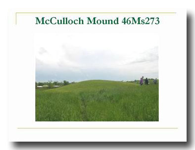 |
In Mason County, several earthen burial mounds and “rock heaps” were excavated. Unfortunately, records from the 1880s do not provide specific provenience information. Many of the artifacts at the Smithsonian from these early excavations have no information associated with them except the county in which they were found. In the Report on the Mound Explorations, Thomas (1985[1894]) states that the entire valley from Kanawha Falls to the mouth of the river contained abundant evidence of mounds and later occupations. On the south side of the Kanawha River approximately five miles above the mouth is the McCullough Mound that was excavated during the BAE explorations. At the time of excavation, the mound was approximately 20 feet high and 300 feet in circumference. Thomas (1985 [1894]) described it as the largest mound in that section of the valley. On top of the mound was a previously disturbed “rock heap” that had contained the remains of a large skeleton with stone tools. This was described as an intrusive burial. Several mounds in the valley had burials in the top that are thought to be from a later population than the people who constructed and used the mounds (Thomas 1985[1894]). A circular shaft 11 feet in diameter was sunk through the top of the mound to the bedrock below. The matrix of the mound was predominantly ash mixed with soil. The natural surface had been covered by a layer of clay, and over that, a layer of bark. Large sandstone slabs were scattered through the shaft interpreted by Thomas (Thomas 1985[1894]) as the remains of a stone roof covering an internal vault. Casts of oak post and roof timbers 6 to 14 inches in diameter were also found. In the ash fill were the remains of at least six adult individuals and several children. The mound was wet at the bottom and the remains were so decayed that it was impossible for the excavators to determine the exact number. The burials were lying parallel with their heads to the west. No personal items were found with the burials (Thomas 1985[1894]).
|
|||||||||||||||
|
Late Pre-Contact Villages In
the 1940s amateur archaeologists in West Virginia began to actively
excavate and collect the many archaeological sites along the Kanawha and
Ohio Rivers. Every time a field was plowed new artifacts were discovered. Quite
a few of these sites were Indian villages with burials. The amateurs
collected and excavated at the sites for years and when the West Virginia
Archaeological Society was formed in 1949, they became charter members.
There were no professional archaeologists in West Virginia until the
1960s. Some of the amateurs kept meticulous records and catalogues of
artifacts they found and in many cases that is all that remains of the
sites. When
an archaeological site is recorded with the State Historic Preservation
Office, it is given a three part number known as its trinomial
designation. The first part represents the state, in this case 46 for WV.
The second part indicates the county, for example, MS for Mason, and the
third part is the number in sequence of sites recorded in the county.
At the present time, approximately 300 archaeological sites have
been recorded for Mason County. The
village sites were occupied during the Late Pre-Contact period,
approximately A.D. 1000 to 1650. In the Ohio Valley they were part of what
archaeologists call the Fort Ancient Tradition. Fort Ancient villages were
usually circular, with square or rectangular houses built around an open
central plaza. The villages were located on the floodplain or terraces of
major rivers. Many later villages were enclosed within a palisade wall for
protection. The
villagers were farmers, raising corn, beans, and squash. They hunted a
variety of fish and wild game, the most common of which was the
white-tailed deer. Contrary to what many people believe, no buffalo
remains have ever been found from this time in West Virginia.
It appears that the buffalo came into the valley later, probably
after the villages were no longer occupied. They
hunted game with bows and arrows tipped with triangular arrow heads
and used a variety of stone, shell, and bone tools and personal ornaments.
Many exotic artifacts have been found from this time, such as the marine
shell gorget, that originated in the Southeast, and copper items such as
hair tubes, bracelets, and tinklers that were probably attached to
clothing. Native copper was imported from the Great Lakes region or
Virginia. They made and used a variety of types of pottery tempered with
mussel shell for food preparation and storage. Musical instruments such as
turkey bone whistles and bone rasps have also been found. |
||||||||||||||||
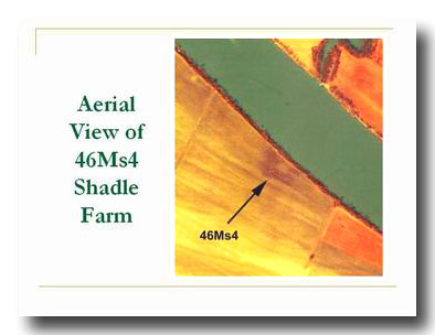
Shadle Farm (46MS4)One of these village sites is Shadle Farm. The site is located on the southern floodplain of the Kanawha River directly across from the mouth of Eightmile Creek. The site was recorded early and excavated and surface collected for many years. The current property owner would not allow access to the site, but it is plainly visible on aerial photography. The dark ring indicates the location of the circular village around an open central area. |
 |
|||||||||||||||
 |
from Shadle Farm.
|
|||||||||||||||
|
||||||||||||||||